| Questions
to be answered |
|
As
summarised on the previous page, Martin Biddle came to the conclusion
that the village of Seacourt consisted of a number of dwellings, stretched
out along both sides of a central road.
He
also mentions the 'typical' Seacourt house, being some 25
ft by 14 ft, thatched, with hearth and no internal partitions.
However,
the site was last looked at nearly 40 years ago under the pressure
of being a 'RESCUE' excavation due to the impending western
by-pass construction.
It must be remembered that any information
gleaned from a site can only be as accurate as the evidence recovered
and the techniques available at the time. Over 40 years have passed
and technology, ideas and archaeology itself have progressed.
Seacourt is just one of a number of
sites that has potentially more information to offer us than what
was published in its original report. It is for this reason that we
are once again 're-examining' these sites by means of reviewing the
available documentary and material evidence.
|
|

' What is meant by the term RESCUE archaeology?
'
The
majority of excavations carried out in Britain today fall
under the category of Rescue Archaeology. With an ever
increasing rate of development, a need to record the archaeological
information of sites, particularly those in towns, quickly
and efficiently, is needed:

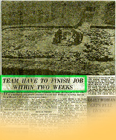
source:
Oxford News, 1958
Seacourt
was one such a site, with the need to gather as much information
as possible before the bulldozers arrived, scraping the whole
area flat in preparation for the western by-pass. The photograph
shows Area 4. |
|
|
Methodology |
|
One
of the first things to be done when examining any archaeological site
is to analyse stratigraphical make-up. However, much of Seacourt was
unstratified, other areas were very complex, and due to the four-week
placement, a comprehensive study was not undertaken by this author.
|
|

'What is stratigraphy ?'
One
of the first principles of archaeological interpretation states
that where one deposit overlies another, the uppermost layer
must have accumulated later in time than the lower, which
could not have been inserted beneath a layer already there
(See Fig. 4.1 below). |
|
|
For this case-study we are going to
take a closer look at two areas of Seacourt, comparing the excavated
ceramic material of both to see if there are any significant differences
which could perhaps lead us to a greater understanding of the function
of the structures within.
|
|
Area
11 Almost
exactly in the centre of the village, a stone building probably of early
14th century date was discovered. The plan is quite clear,
with evidence of a cobbled entrance both inside and outside the building,
eventually merging with the paved street. Inside the building against
the back wall was a large oval hearth of burnt clay replacing an earlier
hearth. On the right of the entrance was a stone-built drain falling
towards the cobbled area. A semi-circular feature attached to the north
end of the building was thought to be a staircase.
This building is
quite different from the others excavated at Seacourt it is larger,
it may have had an upper storey and it is situated at the centre of
the village. Therefore, Biddle
suggests it may have been an inn.
|
|
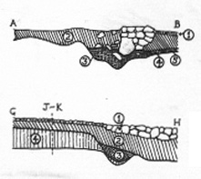
Figure 4.1
Sections
from Area 11, 1958/59
The
stratified sections of Area 11 can be seen clearly from these
diagrams drawn by Martin Biddle, 1963.

source: Biddle (1963)
Check against the pop-up map of Seacourt, (Fig. 3)
to locate the section points of Area 11. |
|
|
Area 4
was described as a typical Seacourt house. Therefore, Area 4 was selected
as a comparative measure to that of Area 11.
It is likely that the material excavated
from the site of a house would differ from that excavated from the
area of an inn. The
possibility of Area 11 actually being an inn is rather interesting
and will form the basis for our question to be answered.
It is extremely difficult
to be 100% confident as to the function of a building through examination
of potsherds and ground plans alone. However, through the use of visual
and statistical analysis, we can elucidate whether, for example, a difference
in activities between the two areas might be reflected in different
proportions of ceramic materials.
|
|
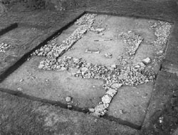
Figure
4.2
Photograph
revealing the ground plan of the typical house in Area 4,
1958/59.

source: Biddle (1963) |
|
