|
Being one of the
first deserted medieval settlements to be extensively excavated, the site of
Seacourt promised to provide important evidence in connexion with the
chronology of medieval pottery and small finds.
Additionally, the
excavations, notably those in the line of the impending Western by-pass
project in 1938/39 by Rupert Bruce-Mitford and then later
in 1958/59 by Martin Biddle, cast new light on medieval
economic history and of conditions at the end of the 14th
century when important changes were taking place in the status of the
English peasantry.
|
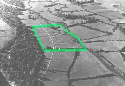
Figure
2.
Seacourt, 1938/39
Seacourt Area Oblique Photograph, 1951, (Courtesy
of Allen Aerial Photographic Archive)
Place:
Seacourt
DMS
NGR:
SP
460 080
Parish:
Wytham
District:
Vale of White Horse
County:
Oxfordshire
|
|
|
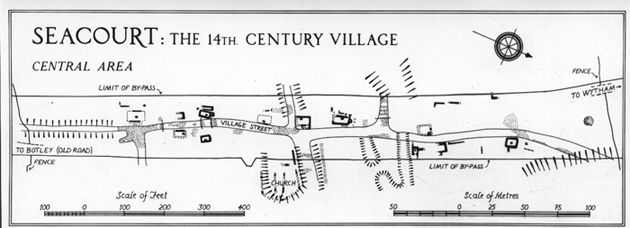
Chronology
The position of the early
nucleus of settlement has not so far been located. It may have lain in the
south-eastern part of the village; however, the trial trenches dug in 1939
did not reveal any clear indication of dates earlier than the 12th
century.
The evidence from Areas
1,2,5,6 and 11 suggest the village expanded greatly to the north and
west towards the end of the 12th century, reflecting the
rising population and land hunger which reached its height in the later
13th century (Beresford, 1954). During this time, a shift
from timber construction towards that of stone was observed.
Economy
Apart
from the probable byre in Area 1 and the wooden barn-byre in Area 5,
the structures excavated at Seacourt were dwellings. The only traces
of industrial processes were those of iron-smelting in Area 31. Agriculture
and animal husbandry were clearly the main occupations.
|
The Seacourt house
The early 13th
century house in Area 5 is so similar in size and plan to the later
stone houses that it may be safe to assume it is representative of the
typical Seacourt house. It is a rectangular structure, about 25 ft by
14 ft internally, with a single hearth either centralised or against
the middle of the rear wall, with no sign of any partitions or walls.
In no cases were enough roof-tiles found to suggest anything but a thatched
roof.
Unlike the typical medieval
long-house, the Seacourt houses had no provision for accommodating animals.
Instead, it seems likely that animals were kept in subsidiary buildings,
examples of which have been associated with most of the stone houses and
also the timber house of Area 5. The origins of this type of farm-unit,
surely differing from those which gave rise to the long-house, at present is
unclear.
|
|
Village
planning
There is little evidence
for a coherent plan of the village until the middle of the 13th
century, at which time the paving of the north-south street defined
the future main access of this part of the village. However, timber
structures in Areas 1 and 5 suggest positioning about an earlier boundary
of the same location. All the excavated stone buildings seem to be laid
out in relation to this north-south street, on to which the doors of
the houses probably opened. In some cases, the houses seemed to have
faced each other, as if laid out in pairs.
|